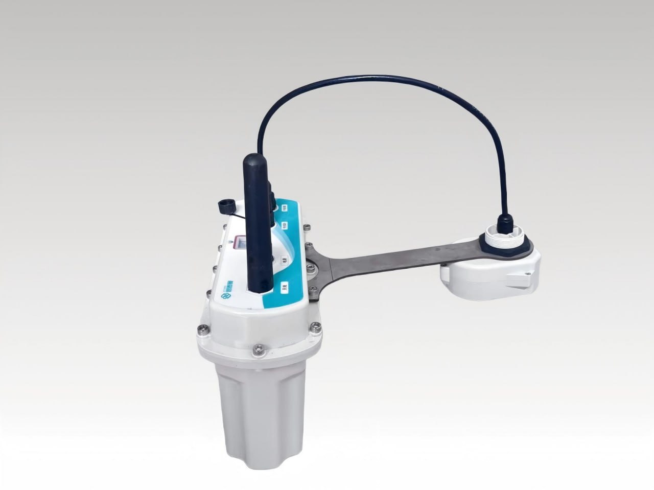
Visual Fusion Radar Water Level Gauge
The Visual Fusion Radar Water Level Gauge series is independently innovated and developed by Ecolor. Notably, the device breakthrough integrates a hig...
Key Features
Performance Metrics
| Battery | 96AH (Expandable) |
| Housing | Made of corrosion-resistant, acid/alkali-resistant, impact-resistant material, suitable for use in sewage pipe networks |
| Resolution | 5 Megapixels |
Key Features
Visual Fusion Radar Water Level Gauge Overview
The visual fusion radar water level gauge series is independently innovated and developed by Ecolor for online monitoring in urban stormwater and sewage pipe networks, river discharge outlets and similar scenarios. It employs 76-81GHz Frequency Modulated Continuous Wave (FMCW) radar technology and delivers ±1mm measurement accuracy over a large measurement range up to 65 meters, with a blind zone as low as 10 cm. The breakthrough of this visual fusion radar water level gauge is the integrated high-definition camera: while traditional radar only shows waveforms, Ecolor's radar shows the actual site, solving the industry pain point of focusing only on data, not the site. Users can intuitively monitor water level and environmental dynamics without being physically present. The overall housing is made of corrosion-resistant, acid-alkali resistant and impact-resistant materials with an IP68 protection rating, suitable for use in sewage pipe networks.
Working Principle of the Visual Fusion Radar Water Level Gauge
The visual fusion radar water level gauge transmits FMCW millimeter-wave radar signals toward the liquid surface inside a manhole or channel. A millimeter-wave RF chip enables a more compact RF architecture, a higher signal-to-noise ratio and a smaller blind zone, while the 4GHz operating bandwidth provides higher measurement resolution and accuracy. Leveraging the technical advantages of the high frequency band and wide bandwidth, the visual fusion radar water level gauge can accurately capture water level data with outstanding measurement precision. By processing the reflected signal, the gauge accurately captures the water level from 0.1 m up to 65 m with ±1mm accuracy. Alongside the radar data, the integrated HD camera performs periodic and real-time underground well photography and uploads the images, and the device uploads underground well liquid level data on a timed schedule or in real time. When the water level rises and submerges the device, an alarm is triggered automatically to warn operators of overflow or flooding conditions.
Key Features of the Visual Fusion Radar Water Level Gauge
The visual fusion radar water level gauge combines precise radar measurement with on-site visualization and low-power operation:
- 76-81GHz FMCW radar technology with ±1mm measurement accuracy and a measurement range of 0.1 m to 65 m.
- Blind zone as low as 10 cm, supported by the millimeter-wave RF chip with higher signal-to-noise ratio.
- 4GHz operating bandwidth for higher measurement resolution and accuracy.
- Integrated HD camera for visual remote monitoring, with periodic and real-time underground well photography.
- Beam angle of 6° (horizontal 14°, vertical 10° at -3dB), minimizing interference from the installation environment and making installation more convenient.
- Integrated lens design with compact size.
- Low power consumption operation with battery life greater than 2 years; expandable power supply capacity based on actual needs.
- One RS485 communication channel supporting water quality monitoring data transmission.
- Alarm triggered when the water level submerges the device.
Technical Specifications
Radar Technology
76-81GHz FMCW
Measurement Range
0.1 m to 65 m
Accuracy
±1mm
Blind Zone
As low as 10 cm
Beam Angle
6° (-3dB: H14°, V10°)
Bandwidth
4GHz
Protection Rating
IP68
Battery Life
>2 years (expandable)
Communication
1× RS485
Applications of the Visual Fusion Radar Water Level Gauge
The visual fusion radar water level gauge is designed for online monitoring of urban stormwater and sewage pipe networks, where it measures manhole liquid levels and photographs the well interior without requiring anyone to enter. It also serves river discharge outlets and similar water level monitoring scenarios. Timed and real-time upload of underground well liquid level data supports flood warning, drainage management and network-level analysis, while the alarm triggered when the water level submerges the device provides early warning of overflow events. Through its RS485 communication channel, the visual fusion radar water level gauge can additionally support water quality monitoring data transmission, making each installation point a more complete monitoring node. The corrosion-resistant, acid-alkali resistant and impact-resistant housing with IP68 protection suits the aggressive environment of sewage pipe networks, and the integrated HD camera helps operators distinguish genuine level changes from foam, floating debris or other on-site disturbances that can confuse waveform-only radar readings.
Installation and Maintenance
The visual fusion radar water level gauge is equipped with a dedicated bracket fixing device and requires no on-site wiring, which greatly simplifies the installation process and enhances operational convenience. Installation without entering the manhole greatly improves personnel and equipment safety and also facilitates later operation and maintenance. The narrow 6° beam angle minimizes interference from the installation environment, so alignment inside the well is straightforward, and the compact integrated lens design keeps the device small. After installation, periodic and real-time photography lets maintenance teams check conditions remotely, and with battery life over 2 years under low power consumption operation, routine service visits stay infrequent; if the power supply capacity needs to grow, it can be expanded based on actual needs.
Why Utilities Choose Visual Fusion Radar Level Monitoring
For urban drainage authorities, the visual fusion radar water level gauge removes the need for manhole entry during both installation and routine inspection. Scheduled and real-time photographic records of underground conditions are uploaded automatically, so engineers can verify water level, debris, and equipment status from the monitoring platform instead of dispatching field crews. When the rising water level submerges the device, an alarm is triggered automatically, giving operators early warning before flooding spreads through the pipe network.
The RS485 communication channel also carries water quality monitoring data, allowing one installation point to serve both hydraulic and water quality supervision. Because the power supply capacity can be expanded according to actual site needs, the same platform fits shallow inspection wells in residential districts and deep trunk sewers with longer battery life requirements.
? Reference Sources
- Ecolor Industrial Product Documentation
- FMCW Radar Technology Specifications
- Urban Drainage Monitoring Industry Standards
Contact Us
Need a custom solution? Our engineers are ready to help you design the perfect system.
Get In Touch