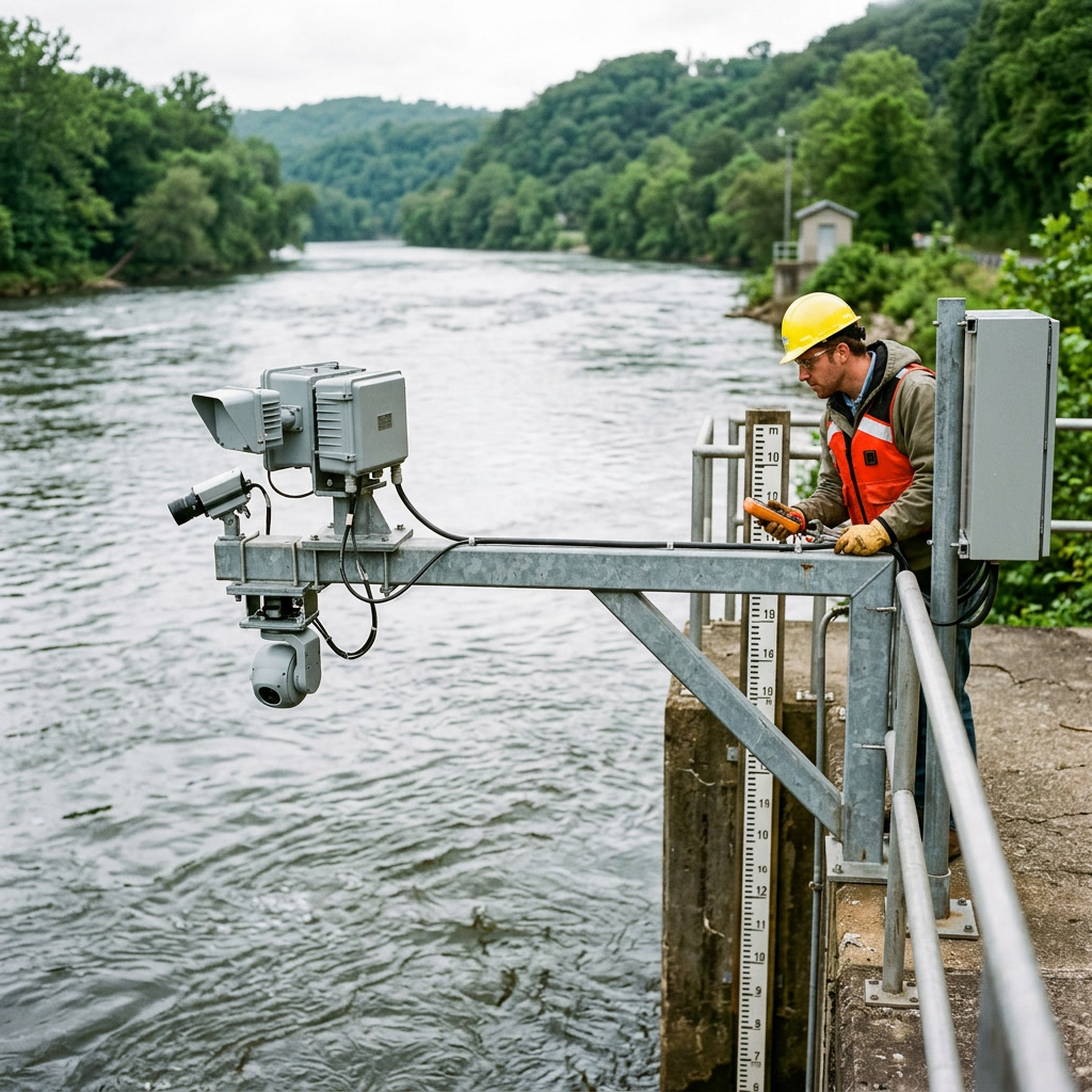
Application Scheme of Multi-Band Doppler Radar Flowmeter for Surface Velocity Measurement in Natural River Channels at National Hydrological Stations
To address the challenges of manual wading operations for flow velocity measurement in natural river channels at national hydrological stations, insufficient measurement frequency during flood peaks, vulnerability of traditional rotor-type current meters to damage under high-flow and high-velocity conditions, and delays in the timeliness of measurement data, a multi-band Doppler radar flowmeter is adopted to continuously measure surface flow velocity in natural river channels in a non-contact manner. Combined with synchronized water level data from a radar water level gauge and the SITUMAN hydraulic COSP model for automatic cross-section discharge estimation, this system achieves fully automated online measurement of all key elements—"water level, surface velocity, and discharge." During flood peak events, the measurement frequency is enhanced from manual intervals of several hours to continuous minute-level densification, eliminating the need for personnel to wade into the water. This provides highly timely and traceable continuous discharge data sequences for hydrological forecasting and national water resources assessment.
Overview
Summary
To address the challenges of manual wading operations for flow velocity measurement in natural river channels at national hydrological stations, insufficient measurement frequency during flood peaks, vulnerability of traditional rotor-type current meters to damage under high-flow and high-velocity conditions, and delays in the timeliness of measurement data, a multi-band Doppler radar flowmeter is adopted to continuously measure surface flow velocity in natural river channels in a non-contact manner. Combined with synchronized water level data from a radar water level gauge and the SITUMAN hydraulic COSP model for automatic cross-section discharge estimation, this system achieves fully automated online measurement of all key elements—"water level, surface velocity, and discharge." During flood peak events, the measurement frequency is enhanced from manual intervals of several hours to continuous minute-level densification, eliminating the need for personnel to wade into the water. This provides highly timely and traceable continuous discharge data sequences for hydrological forecasting and national water resources assessment.
Key Advantages
Challenges
- During flood peaks, high flow velocities and abundant floating debris make manual wading and cableway operations extremely hazardous, forcing flow measurement interruptions and creating data gaps.
- Manual flow measurement takes 1–3 hours per operation, resulting in insufficient measurement frequency during flood seasons and distortion of the rising limb and peak processes.
- Rotary current meters are prone to damage and entanglement in high-velocity, debris-laden flows, while ADCPs struggle to maintain stable orientation during extreme flood events, leading to both equipment loss and data gaps.
- Single-band radar is susceptible to interference from wind waves and raindrops, and surface velocity coefficients are empirically estimated, making flow calculations insufficiently accurate to meet national gauging station standards.
- Traditional flow measurement lacks on-site visual evidence, making it impossible to reconstruct the hydrological conditions at the time of measurement when data are questioned, complicating review and traceability.
Results
- Flow measurement frequency during flood peaks has improved from manual 4–6 hour intervals to continuous minute-level calculations, significantly enhancing the completeness of flood hydrograph peaks.
- Personnel now perform zero wading operations during high-flow events, substantially eliminating personal safety risks.
- Equipment availability has remained above 99% over two consecutive flood seasons, with data validity maintained above 95% under high-velocity (>4 m/s) and heavy-debris conditions.
- Multi-band anti-interference technology combined with stage-based comparative calibration ensures that systematic errors in flow calculations meet national hydrological station accuracy requirements.
- Measurement data and synchronized 5-megapixel on-site imagery are archived together, providing full visibility and traceability, greatly improving review efficiency.
Solution Details
Multi-Band Doppler Radar Flowmeter: A Non-Contact Solution for Surface Velocity Measurement in Natural River Channels
National hydrological stations are the source of hydrological data production, and the quality of their flow measurement directly determines the credibility of river water volume scheduling, flood forecasting, and water resource assessment. Natural river channels feature wide cross-sections and complex flow regimes. Traditional velocity measurement relies primarily on rotor-type current meters or manual ADCP traversing: these methods are adequate for moderate flow conditions, but during flood peaks—when flow velocities are high, floating debris is abundant, and currents are turbulent—manual wading or cableway operations pose extreme safety risks. As a result, measurement frequency is forced down to once every few hours or even once per day, precisely missing the most critical rising limb and peak segments of the flood hydrograph. The flow hydrograph near the peak can only be estimated through interpolation.
The multi-band Doppler radar flowmeter offers a non-contact solution to this problem: the device is mounted on bridges, cantilever brackets, or cableways above the measurement cross-section, transmitting multi-band radar waves downward. Based on the Doppler shift principle, it directly measures surface flow velocity within the radar beam coverage, with a measurement range of 0.1–20 m/s and resolution of 0.01 m/s, automatically identifying both forward and reverse flow directions. Paired with a non-contact radar water level gauge (range 0.1–40 m, accuracy ±2 mm), the SITUMAN hydraulic COSP hydrodynamic model then converts surface velocity to cross-sectional mean velocity and computes discharge, achieving integrated online measurement of water level, velocity, and flow—three elements in one system. The complete unit features IP68 protection, solar + battery power supply, dual-channel reporting via 4G/NB-IoT, and innovatively integrates a 5-megapixel camera unit with a built-in motor (radar illumination angle adjustable from 15° to 75°), enabling on-demand capture of on-site flow condition imagery—addressing the industry pain point of "managing data only, not the field situation."
Five Major Pain Points in Velocity Measurement at National Hydrological Stations on Natural Rivers
High safety risk during flood measurement: During flood peaks, river flow velocities can reach 3–5 m/s or higher, with floating debris and rolling stones mixed in. Manual wading to deploy current meters or cableway suspension operations can easily lead to safety accidents. Most stations are forced to suspend measurement and wait, leaving gaps in the flow hydrograph.
Insufficient measurement frequency: A single manual flow measurement operation requires 1–3 hours. During flood season, increased measurement frequency is constrained by manpower and equipment limitations. The rising, peak, and recession phases of a flood often yield only scattered measurement points, causing distortion of the flow hydrograph at the peak and directly impacting flood forecasting and regulation decisions.
Traditional instruments are vulnerable to damage under high-velocity conditions: Rotor-type current meters suffer blade damage and entanglement from debris in high-velocity, debris-laden flows. ADCP traversing measurements struggle to maintain attitude stability during high flood periods, resulting in both equipment loss and data gaps.
Coarse conversion between surface velocity and cross-sectional discharge: Single-band radar is susceptible to interference from wind waves, raindrop splash, and floating debris on the water surface. The surface velocity coefficient is empirically assigned without coupled modeling of water level, velocity, and cross-section geometry, making flow computation accuracy insufficient to meet national station assessment requirements.
Lack of on-site visual evidence during measurement: Traditional flow measurement produces only numerical records without the ability to reconstruct the actual field conditions at the time of measurement. When data is questioned, there is no image-based evidence chain, making review and traceability difficult.
"Radar Flow Measurement + Water Level Linkage + COSP Model" System Architecture for Hydrological Flow Monitoring
Non-contact surface velocity measurement layer: The multi-band Doppler radar flowmeter is installed on cross-section control structures (bridges, cantilever brackets, cableways). Multi-band radar frequency-shift technology performs continuous sampling of water surface echoes, with multiple bands providing mutual redundancy verification. False frequency shifts caused by wind waves, raindrops, and floating debris are automatically eliminated, outputting highly reliable surface velocity time-series data with 0.01 m/s resolution and automatic bidirectional flow identification.
Synchronized water level measurement layer: A non-contact radar water level gauge is deployed at the same cross-section, with a range of 0.1–40 m, accuracy of ±2 mm, and resolution of 1 mm. Water level data is time-stamped and aligned with velocity data at the same second-level precision, providing real-time wetted cross-section boundaries for discharge computation.
Flow Calculation Model Layer: The SITUMAN water conservancy COSP hydraulic model incorporates cross-section geometry data and calibrated surface velocity–mean cross-section velocity relationships, dynamically updating the wetted area and velocity coefficient as water levels change, automatically calculating cross-section flow and generating continuous flow hydrographs. During flood seasons, manual comparative measurement data can be overlaid online to correct coefficients, achieving a dual-track quality control system of "continuous machine measurement + periodic manual calibration."
Imagery Evidence and Remote Monitoring Layer: Integrated with a 5-megapixel camera unit, with capture frequency configurable via the backend and manual snapshot support at any time. The radar illumination angle is remotely adjustable via a built-in motor (15°–75°). The platform end supports synchronized viewing of velocity data curves and on-site water condition imagery, ensuring full-process visibility and traceability of measurement operations.
Communication and Power Supply Layer: Dual-channel reporting via 4G/NB-IoT, Modbus standard protocol compatible with hydrological RTUs and telemetry terminals. DC power supply with external solar panel support; built-in battery standby of 10 days, external battery endurance of 2 years, suitable for long-term operation at river sections without mains power.
Key Technologies and Selection Considerations for Radar Flowmeter Deployment
Multi-band Anti-interference Design: Multi-band radar frequency-shift sampling demonstrates significantly higher tolerance to water surface state variations than single-band devices, maintaining continuous effective measurement under raindrop splashing, localized wind waves, and floating debris occlusion—a critical factor for data completeness during high-flow conditions.
Surface Velocity Coefficient Calibration: During initial commissioning, rotor current meters or ADCP manual flow measurement serve as the baseline. Synchronized comparative measurements of surface velocity and mean cross-section velocity are conducted by water level stage, calibrating velocity coefficients for each stage and writing them into the COSP model. Thereafter, verification is performed once before and after each flood season to ensure long-term accuracy.
Installation Geometric Requirements: The radar beam center should be positioned near the main flow line and maximum velocity zone of the cross-section. Beam incidence angle and mounting height are calculated based on range requirements, avoiding bridge pier recirculation zones and dead water areas. The mounting bracket must have sufficient rigidity to ensure beam pointing deviation remains smaller than the measurement zone scale under wind-induced vibration.
Automatic Flood Peak Intensification Strategy: Configured with water level/velocity abrupt-change trigger mechanisms—when the rate of water level rise or velocity exceeds thresholds, the system automatically switches from routine collection to minute-level high-frequency acquisition, with synchronized intensified image capture, fully recording the flood rise and peak processes.
Lightning Protection and Enclosure Protection: Field bridge-mounted installations are equipped with two-stage lightning protection for both power and signal lines. The complete unit features IP68 protection, with ABS/PC/PTFE housing materials resistant to moisture corrosion, adapted to −20–60°C environments (subject to battery specifications).
Typical Application Scenarios for Online Flow Measurement in Natural Rivers
Online Flow Measurement Retrofit for National Basic Hydrological Stations: Retaining manual comparative measurement and verification functions, with routine water level, surface velocity, and flow automatically and continuously measured, data directly connected to provincial and national hydrological data platforms, reducing the workload of grassroots measurement and reporting personnel.
Mobile Emergency Flow Measurement for Flood Control: The lightweight design (total unit weight 1150 g) facilitates rapid deployment. During flood seasons, temporary installations at critical flood-control cross-sections, breach sites, and flood diversion channels provide real-time velocity and flow transmission to support flood control dispatch decision-making.
Monitoring of Small and Medium Rivers and Mountain Torrent Channels: Radar flow measurement stations deployed at outlet cross-sections of torrent-prone channels, integrated with mountain flood warning platforms—sudden increases in velocity and flow trigger immediate warning issuance.
Ecological Flow and Water Volume Assessment Cross-sections: Continuous flow metering at interprovincial boundaries, irrigation district headworks, and ecological water replenishment cross-sections, providing continuous and auditable data chains for water resources assessment, water dispatch, and ecological flow regulation.
Engineering Implementation and Long-term Operation & Maintenance of Radar Flow Measurement Systems
Cross-section Survey and Solution Design: Review cross-section stability and control conditions, select installation points (bridge/cantilever/cableway), calculate beam coverage and installation geometry, and deliver equipment configuration and comparative measurement calibration plans.
Installation, Commissioning, and Comparative Rating: Complete foundation construction for the support structure, equipment installation, and lightning protection & grounding; connect the water level gauge and RTU/telemetry terminal. Conduct staged manual comparative measurements at different water levels, calibrate the surface velocity coefficient, and embed it into the COSP model. Complete a 48-hour continuous operation assessment.
Platform Integration and Acceptance: Integrate data into the hydrological data platform, configure acquisition schedules, automatic flood-peak encryption strategies, and alarm thresholds. Complete accuracy assessment of flow computation results against manual discharge measurement outputs, and deliver as-built documentation and operation & maintenance manuals.
Long-term Operation and Maintenance: Remotely monitor equipment status and data integrity via the platform, with periodic image capture to verify on-site hydrological conditions. Conduct comparative rating reviews, lens cleaning, and bracket fastening inspections before and after flood seasons. Remotely upgrade firmware to ensure full-lifecycle support for national station measurement and reporting quality.
Application Outcomes of Multi-Band Doppler Radar Flowmeter Deployment
After a river basin authority deployed multi-band Doppler radar flowmeters for online flow measurement systems at natural river channel cross-sections across 3 national hydrological stations: the measurement frequency during flood peak processes was upgraded from manual readings every 4–6 hours to continuous minute-level computation, significantly improving the completeness of flood hydrograph peak capture; field personnel performed zero wading operations during high-flow events, substantially eliminating personal safety risks; over two consecutive flood seasons of continuous operation, equipment availability exceeded 99%, and data validity remained above 95% under high-velocity (>4 m/s) and heavy-debris conditions; based on staged manual comparative measurements at different water levels, the systematic error of flow computation met the accuracy requirements for national hydrological station measurement and reporting; all measurement data and on-site imagery were archived synchronously, greatly enhancing data traceability and review efficiency.
0.1–20 m/s
Surface Velocity Range
±2 mm
Water Level Accuracy
IP68
Enclosure Protection
1150 g
Total Unit Weight
15°–75°
Radar Angle Adjustment
5 MP
Integrated Camera
? 参考来源
- National Hydrological Station Measurement Standards and Guidelines
- SITUMAN Hydraulic COSP Model Technical Documentation
- Multi-Band Doppler Radar Flowmeter Product Specifications
- Field Deployment Case Studies from River Basin Authorities
Approach
How we implement intelligence into your infrastructure step by step.
Cross-section survey and solution design
Review cross-section stability and control conditions, select installation points on bridges, cantilevers, or cableways, calculate radar beam coverage and installation geometry, and deliver equipment configuration and comparative calibration plans.
Installation, commissioning, and comparative calibration
Complete bracket foundation construction, equipment installation, and lightning protection grounding; connect water level sensors and telemetry terminals; conduct stage-based synchronous comparative measurements using rotary current meters or ADCP manual measurements as reference, calibrate surface velocity coefficients, and embed them into the COSP model.
Platform integration and accuracy assessment
Integrate data into the hydrological data platform, configure acquisition schedules, automatic flood-peak encryption strategies, and alarm thresholds; complete accuracy assessment of flow calculation results against manual measurements, followed by acceptance and handover.
Long-term maintenance and flood-season revalidation
Remotely monitor equipment status and data integrity via the platform, use image snapshots to verify on-site conditions; conduct pre- and post-flood comparative calibrations of velocity coefficients, perform lens cleaning, bracket tightening, and remote firmware upgrades to ensure measurement quality throughout the entire cycle.
❓ Related FAQs
Related Solutions
Liquid Turbine Flow Meter Solution for Batch Metering of Low-Viscosity Light Oil Products
Ultrasonic Water Meter Solution for DMA District Metering and Leakage Control in Urban Water Supply
Coriolis Flow Meter Solution for High-Precision Micro-Dosing Metering in Chemical Processes

Ready to Optimize Your Business?
Contact us, and our professional team will provide customized solutions to help your business achieve digital transformation.
Get In Touch