How a Water Utility Group Achieves Cost Reduction and Efficiency Improvement Through Irrigation District Informatization
Ecolor Technology In-Depth Industry Report: Breaking Through and Reconstructing the Digital Transformation of Large-Scale Irrigation Districts—A Panoramic Analysis of the Smart Irrigation Project in the Zeyuan Irrigation District, Northwest China
[Introduction] As the industry news editor for Ecolor Technology, we have long been closely following the modernization process of agricultural water conservancy both globally and in China. In recent years, with the comprehensive rollout of national water network construction and the in-depth implementation of the Implementation Plan for the Continuation, Matching, and Modernization Transformation of Large-Scale Irrigation Districts during the 14th Five-Year Plan Period, the digitalization of irrigation districts has transitioned from early "conceptual trials" into the "deep water zone" and "practical application phase." However, across vast fields and in complex natural environments, how can cutting-edge technologies such as IoT, big data, and artificial intelligence be genuinely transformed into actual productive forces in agricultural production? How can we bridge the technological gap from "data acquisition" to "intelligent decision-making"? In this in-depth report, the Ecolor Technology Editorial Department turns its focus to the benchmark of large-scale modern irrigation district transformation in China's arid northwest—the Zeyuan Irrigation District (project code name). Through a panoramic and objective analysis of its project background, underlying technical challenges, system solutions, the entire implementation process, and final operational data, we present the industry with a highly referential practical sample of irrigation district digitalization and smart irrigation engineering.
I. Project Background: The "Water Crisis" and "Management Dilemma" Facing Traditional Large-Scale Irrigation Districts
Located in the core arid inland region of northwest China, the Zeyuan Irrigation District is a large-scale diversion irrigation district initially built in the 1970s. It controls an irrigation area of up to 1.25 million mu, bearing the dual responsibility of building a regional commercial grain base and maintaining the ecological barrier. The district includes 3 main canals (totaling 186 kilometers), 45 branch canals (totaling nearly 600 kilometers), and thousands of lateral and farm canals. The local climate is extreme, with an average annual precipitation of only 155 millimeters, while the annual evaporation exceeds 2,100 millimeters, making it a typical region of resource-based water scarcity. The extreme scarcity of water resources and the rigid demand for water in agricultural development constitute the long-standing core contradiction in this area.
Prior to the implementation of this digital transformation project, the Zeyuan Irrigation District faced an extremely severe traditional management dilemma. First, water resource utilization efficiency was low. Due to the aging of early water conservancy facilities, low standards for canal seepage control, and the long-term use of extensive flood irrigation methods, the canal system water utilization coefficient was only about 0.45. This means that over half of the precious water resources were lost to seepage or evaporation during conveyance, distribution, and irrigation. Second, water measurement methods were extremely backward. Traditional water staff gauges were installed only at the head of the main canal and a few major diversion hubs. Staff relied on visual observation of the gauge scales and combined this with empirical formulas to estimate flow rates. This method not only had an error rate as high as 15% to 20%, but the data also suffered from severe lag, making it impossible to support refined water rights allocation and water fee collection.
In addition, the operation and management of the irrigation district were highly dependent on manual labor. During peak irrigation periods, the district management office had to dispatch hundreds of canal patrolmen and gate operators, riding motorcycles or even hiking across hundreds of kilometers of canals to manually crank heavy gate hoists to adjust the gates. This "human sea tactic" not only involved high labor intensity and safety risks, but there was also a huge time lag in the issuance and execution of dispatch instructions. From the time a water dispatch command was issued by the management center to the time the end-point gates completed their adjustments, it often took 2 to 3 days, leading to frequent mismatches in supply and demand, such as "upstream flooding while downstream faces water shortages." Faced with the increasingly tightened total water use control indicators (red lines) for river basins, the original extensive management model of the Zeyuan Irrigation District had reached its end. Seeking benefits through informatization and intelligence, and implementing comprehensive water-saving transformation and smart irrigation upgrades, became the only way out for the survival and development of the irrigation district.
II. Technical Challenges: Water Measurement and Data Transmission Challenges in Complex Field Environments
Implementing digitalization in the vast and harsh wilderness of the northwest is by no means as simple as transplanting urban IT systems to rural areas; the engineering and technical challenges are multi-dimensional and extremely complex. During our research, Ecolor Technology found that the Zeyuan Irrigation District project team encountered four major core technical obstacles during the initial survey.
- The first major challenge lies in the adaptability of precise open-channel water measurement technology. Unlike closed pipelines, the flow patterns in open irrigation canals are extremely complex. Canals often suffer from weed overgrowth, sediment deposition, and abundant floating debris; meanwhile, influenced by canal slope and gate opening, water flow frequently transitions between rapid flow (supercritical flow) and tranquil flow (subcritical flow), resulting in highly unstable flow regimes. Traditional ultrasonic transit-time flowmeters experience severe signal attenuation or even loss when dealing with high-sediment water bodies; while radar velocity sensors exhibit significantly amplified errors in extracting surface flow velocity when the water surface is calm or subjected to wind interference. Ensuring that flow measurement accuracy remains stable within ±5% under various harsh flow regimes and sediment conditions is the primary challenge.
- The second major challenge is the "blind spots" and stability of the communication network. Stretching for hundreds of kilometers, the Zeyuan Irrigation District has many branch and lateral canal gates located in remote gobi deserts or deep within farmlands, where the coverage of 4G/5G public networks from the three major carriers is less than 60%. In areas without network signals, even if sensors collect high-precision hydrological data, it cannot be transmitted back to the management center; similarly, intelligent dispatch instructions from the cloud cannot be sent to the on-site gates. The traditional approach of laying optical cables faces extremely high construction costs and a high risk of later damage due to the long battle lines and the numerous villages and farmlands they cross.
- The third major challenge is the power supply guarantee for field equipment and its tolerance to extreme climates. In the northwest region, winter temperatures can drop to minus 25 degrees Celsius, while summer surface temperatures can soar above 60 degrees Celsius, often accompanied by sandstorms. Most field measurement and control stations cannot be connected to the municipal power grid and must rely solely on solar power. During continuous rainy, snowy, or overcast days, or when solar panels are covered by sand and dust, how can the normal operation of on-site control cabinets, communication gateways, and heavy gate hoists be ensured? The capacity of conventional industrial-grade batteries plummets dramatically under extreme cold conditions, posing a huge challenge to the all-weather reliable operation of the system.
- The fourth major challenge lies in the integration of "information silos" and the underlying data architecture. Over the past decade or so, the irrigation district had sporadically purchased meteorological stations, soil moisture sensors, or financial billing software from different manufacturers. These systems operated independently, with inconsistent data standards and mutually closed interfaces. The newly built smart irrigation platform must possess strong compatibility to break down the data barriers of these legacy systems, achieving end-to-end data integration from weather forecasting, soil monitoring, and water rights allocation to gate control and water fee settlement.
III. Overall Solution: Building a "Cloud-Edge-Device" Collaborative Smart Irrigation District Brain
Addressing the above complex pain points, the project contractor collaborated deeply with research institutes to tailor a modern comprehensive informatization solution for the Zeyuan Irrigation District based on a "cloud-edge-device" collaborative architecture. This solution abandons the traditional hardware-stacking model of "treating the head when the head aches and the feet when the feet hurt," and instead starts from top-level design to build a "smart irrigation district brain" equipped with holographic perception, edge autonomy, and cloud-level coordination capabilities.
The "Device" Layer
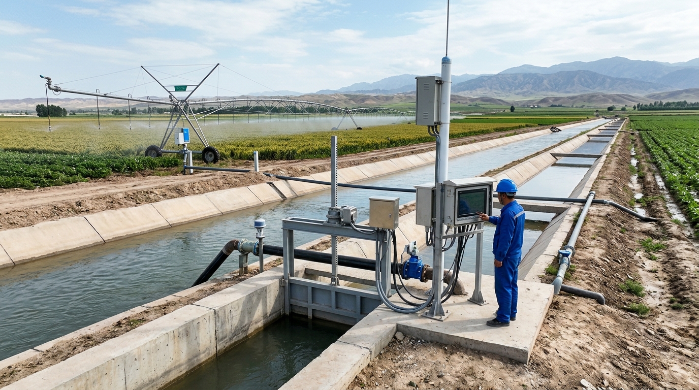
At the holographic perception and execution network layer, the engineering team deployed a dense network of nerve endings within the irrigation district. This includes 350 sets of integrated smart measurement and control gates installed at key nodes of the main and branch canals. In the farmland areas, 1,200 sets of multi-layer soil moisture, temperature, and conductivity sensors and 80 sets of micro agricultural meteorological stations were deployed in a grid pattern. All these edge devices adopt the highest IP68 waterproof and dustproof design.
The "Edge" Layer
At the edge computing and converged communication layer, the solution innovatively introduces water conservancy edge computing gateways. At each major diversion hub, edge nodes with AI computing power are deployed. When the communication network is interrupted, the edge gateway can autonomously control the opening and closing of on-site gates. A heterogeneous converged network of "4G/5G public network + LoRaWAN self-organizing network + BeiDou short message service" is adopted to guarantee seamless communication.
The "Cloud" Layer
At the intelligent decision-making and digital twin platform layer, the project has built a comprehensive management cloud platform based on a microservices architecture. This "digital twin" system integrates 3D GIS, BIM models, and real-time IoT data. By aggregating meteorological satellite data, soil moisture data, and flow data, the cloud brain performs multi-dimensional complex calculations to automatically generate the optimal water distribution and dispatch plan.
IV. Core Technological Breakthroughs: Deep Integration of Precise Water Measurement and Smart Irrigation Algorithms
Throughout the digital transformation project, the breakthrough in water measurement technology and the implementation of smart irrigation algorithms are the core keys to determining the success or failure of the project. The Ecolor Technology Editorial Department believes that the engineering practices of the Zeyuan Irrigation District project in these two dimensions represent the frontier level of domestic agricultural water conservancy informatization.
In terms of precise water measurement, the project team did not adopt a single measurement device, but developed an "adaptive flow measurement technology with multi-source data fusion." For main canals and large branch canals, due to the wide water surface and large flow rates, the project adopted a combined solution of "multi-path ultrasonic transit-time method + radar surface velocity sensor." Multi-path ultrasonic sensors are installed in a cross "X" pattern on both sides of the canal, capable of layered scanning of the true flow velocity distribution inside the water body; meanwhile, radar wave sensors suspended above monitor surface flow velocity and water level in real time. The edge computing gateway incorporates a Kalman filtering algorithm. When the sediment concentration in the water body surges, causing ultrasonic signal attenuation, the system automatically increases the weight of radar velocity data; conversely, when strong winds cause waves on the water surface, interfering with the radar, the system relies more on the ultrasonic underlying flow velocity data. In addition, to address the issue of changes in the cross-sectional flow area caused by sediment deposition in the canal, the system introduces an Acoustic Doppler Current Profiler (ADCP) for regular patrol measurement and calibration, dynamically correcting the water level-flow area (A-H) curve, thereby ensuring that the flow measurement error is strictly controlled within ±3% under all-weather and all-flow regimes, truly achieving "counting every drop of water."
At the level of smart irrigation algorithms, the project has achieved a revolutionary shift from "water supply by the day" to "water supply on demand." The core of the cloud platform is the introduction of a real-time calculation model for reference crop evapotranspiration (ET0) based on the Penman-Monteith equation. The system automatically obtains refined meteorological forecast data from the Central Meteorological Observatory for the next 7 days every day, combines it with local crop types (such as winter wheat and seed corn), and the crop coefficient (Kc) corresponding to the current growth stage (such as jointing stage, heading stage, and grain filling stage), to accurately calculate the actual daily water consumption (ETc) of the farmland.
Moreover, the algorithm is deeply integrated with soil dynamic parameters. When the data returned by soil moisture sensors buried at 20cm, 40cm, and 60cm underground in the farmland shows that the soil volumetric water content is approaching the crop's capillary break water content (the critical point at which the crop begins to suffer from drought), the system will automatically trigger an irrigation warning. At this point, the cloud dispatch model will comprehensively consider the current available storage capacity of the reservoir, the water conveyance capacity of the main canal, and the water use quota of each branch canal, using a Genetic Algorithm to solve for the globally optimal water distribution plan within minutes. This plan details which gate should be opened at what exact time and minute, at what angle, and for how long. This algorithmic system, which deeply integrates agronomy (crop water demand patterns), hydraulics (canal system water conveyance routing), and operations research (optimal resource allocation), is the soul of the Zeyuan Irrigation District's realization of true smart irrigation.
V. Implementation Process: Standardized and Refined Engineering Practice from Blueprint to Reality
A grand informatization blueprint must rely on rigorous and solid engineering implementation to take root. The digital transformation project of the Zeyuan Irrigation District lasted for 18 months, during which countless on-site difficulties were overcome. Its standardized implementation process provides valuable reference experience for the industry.
- The first phase was detailed on-site surveying and civil engineering transformation (Months 1-4). Due to the aging of the irrigation district, the slopes of many canals had collapsed, and directly installing high-precision flow measurement equipment would lead to severe data distortion. The construction team first carried out standardized civil engineering transformation on the selected 350 measurement and control cross-sections, pouring U-shaped or trapezoidal flow measurement flumes that meet fluid dynamics requirements, and setting up straight sections of sufficient length upstream and downstream to stabilize the flow. In the severe cold of minus ten-plus degrees in winter, the construction team adopted measures such as erecting insulated sheds and using anti-freeze concrete to rush to complete all underwater civil engineering works before the spring irrigation.
- The second phase was the precision installation and calibration of hardware equipment (Months 5-9). To solve the power supply problem in remote areas, the engineering team customized a microgrid system of "high-power monocrystalline silicon solar panels + lithium iron phosphate cold-resistant battery packs + intelligent charge and discharge controllers" for each on-site station based on local sunshine conditions, ensuring that the equipment can still operate at full load during 15 consecutive rainy days. In the calibration of flow measurement equipment, technicians used a total station to accurately scan the 3D coordinates of each cross-section when the canal was dry and entered them into the system; after the canal was filled with water, they braved the scorching sun and used portable flow meters to conduct manual comparative measurements and parameter calibration at different water level gradients for several weeks, ensuring the absolute reliability of the basic data.
- The third phase was network joint debugging and customized development of platform software (Months 10-14). The focus of this phase was to open up the data links. The implementation team erected multiple LoRa base stations at high points in the irrigation district and used drones carrying signal testers to check the signal strength of thousands of nodes one by one, deploying relays to fill in blind spots. At the same time, the software development team was stationed at the irrigation district management office, eating and living with frontline dispatch personnel to deeply understand their real pain points in daily work. Based on this frontline feedback, the development team iterated the software UI multiple times, encapsulating complex professional models in the backend, while presenting operators in the frontend with intuitive GIS maps, traffic-light-style warning prompts, and "one-click" gate operation buttons, greatly lowering the threshold for system use.
- The fourth phase was trial operation, extreme stress testing, and comprehensive staff training (Months 15-18). During the trial operation, the system withstood the severe test of a sudden summer rainstorm and flash flood. At that time, a sudden rainstorm hit the upstream of a main canal, causing the water level to surge within half an hour. The system's edge gateway instantly captured the abnormal water level exceeding the limit. Under the extreme condition where public network communication was interrupted by the rainstorm, the edge gateway autonomously triggered emergency flood diversion instructions according to the preset flood control emergency plan, automatically opening three drainage gates along the line, successfully avoiding a major accident of main canal dike breach. This real-world case completely won the trust of the irrigation district management personnel in the system. Subsequently, the project team conducted systematic training in batches for over 300 employees in the irrigation district, ensuring that every grassroots water manager could proficiently use the mobile APP for daily inspections and data viewing.
VI. Data Empowerment: Final Effects of Water Saving and Efficiency Enhancement and In-Depth Analysis of Quantitative Indicators
After two complete irrigation seasons of actual operation, the digital transformation project of the Zeyuan Irrigation District has handed in an extremely brilliant "report card." By analyzing the detailed operational data provided by the irrigation district management office, Ecolor Technology clearly sees the huge economic, ecological, and social benefits that digital technology has brought to traditional agricultural water conservancy.
The most core indicator is reflected in the astonishing water-saving results. Thanks to precise water measurement and on-demand intelligent allocation, the past "flood irrigation" and "leakage and loss" have been completely eliminated. Data shows that the canal system water utilization coefficient of the irrigation district has been significantly increased from 0.45 before the transformation to the current 0.59. This means that, with the same total volume of diverted water, more water resources are effectively delivered to the fields. According to statistics, in the first year of system operation, the entire irrigation district achieved agricultural water savings of up to 85 million cubic meters. These 85 million cubic meters of water resources not only alleviated the pressure of regional groundwater over-exploitation but were also exchanged for local industrial development and ecological wetland water replenishment, generating huge comprehensive benefits.
In terms of operation and management efficiency, the improvement can be described as disruptive. In the past, a full-irrigation district-scale water distribution dispatch, from formulating the plan to issuing instructions level by level, and then manually adjusting hundreds of gates, took at least 72 hours and was highly prone to human operational errors. Now, through the one-click intelligent dispatch of the cloud platform, the optimal dispatch plan can be generated in seconds, and the 350 smart gates can all be automatically adjusted to the target opening within 2 hours, increasing dispatch efficiency by nearly 40 times. At the same time, the working mode of frontline canal patrolmen has undergone a fundamental change. They no longer need to blindly patrol the entire line every day, but instead carry out "precision dispatch" based on the alarm information pushed by the mobile APP (such as a gate jamming at a certain location or abnormal water level in a certain section of the canal). It is estimated that the direct operating costs of the irrigation district, including annual vehicle fuel costs, equipment maintenance costs, and labor overtime costs, have decreased by about 42%.
More importantly, precision irrigation has directly promoted agricultural yield increase and income growth. Through the combination of soil moisture monitoring and crop water demand models, crops can receive timely and appropriate water supplementation during critical growth stages (such as the jointing stage of wheat and the tasseling stage of corn), avoiding the yield reduction caused by water shortage in the past or root hypoxia caused by excessive watering. Sampling survey data shows that in the demonstration area where smart irrigation is implemented, the average yield of winter wheat per mu has increased by 11.5%, and the average yield of seed corn per mu has increased by 14.2%. At the same time, due to the strict implementation of the volume-based charging mechanism (water rights trading), farmers' awareness of water conservation has been fully stimulated, and the proportion of farmers actively adopting efficient water-saving facilities such as drip irrigation and micro-sprinkling has significantly increased, forming a virtuous cycle of "engineering water saving" and "management water saving." In the past, disputes over "water grabbing" between upstream and downstream villages, often caused by uneven water resource distribution, have completely disappeared due to the openness and transparency of data.
VII. Operation & Maintenance and Long-Term Mechanism: Ensuring the Healthy Operation of the Informatization System Throughout Its Life Cycle
In the field of agricultural water conservancy informatization, there has long been a chronic disease of "valuing construction over operation and maintenance," causing many costly systems to become neglected "unfinished projects" or "display bonsais" after a few years of operation. The key to the Zeyuan Irrigation District project's ability to continue to exert its effectiveness lies in the simultaneous construction of a scientific and rigorous normalized operation and maintenance and long-term management mechanism at the initial stage of the project.
At the technical level, the system introduces a Predictive Maintenance mechanism for equipment. The platform not only monitors hydrological data but also collects in real time equipment health data such as the operating current, voltage, and torque of gate motors, as well as the packet loss rate of communication gateways and the number of battery charge and discharge cycles. Through big data analysis, the system can issue early warning work orders to operation and maintenance personnel before the motor bearings suffer severe wear or the battery life is about to be exhausted. This shift from "post-failure repair" to "pre-failure prevention" has greatly reduced the sudden failure rate of equipment, ensuring that the system availability during peak irrigation periods reaches over 99.9%.
At the management level, the irrigation district management office, in conjunction with the contractor, jointly compiled the "Standard Operating Procedures (SOP) for Modern Irrigation District Informatization Systems" and the "Equipment Inspection and Maintenance Manual," which are hundreds of pages thick. In view of the reality that grassroots water managers are relatively old and have weak IT skills, the contractor not only provided one-time handover training but also set up a three-year "on-site + remote" accompanying service. On-site engineers regularly organize on-site practical exercises, teaching employees step by step how to clean sediment from sensor probes and how to restart communication modules; at the same time, a 7x24-hour remote technical support center was established to answer operational questions at any time and conduct remote diagnostics of the software backend.
In addition, the irrigation district has also actively explored business model innovation for informatization operation and maintenance. They outsourced some non-core hardware inspection and maintenance work to professional third-party IoT operation and maintenance companies through government purchase of services, while the management personnel of the irrigation district itself focused their main energy on core businesses such as water rights dispatch, water fee collection, and agricultural services. By clarifying rights and responsibilities and formulating strict SLA (Service Level Agreement) assessment indicators, the Zeyuan Irrigation District has established a long-term operation and maintenance system with guaranteed funding, technical support, and a talent pipeline, injecting lasting momentum into the healthy operation of the system throughout its life cycle.
VIII. Industry Outlook: The Modernization Future of Irrigation Districts in the Era of Digital Twins and Large Models
[Outlook] The successful practice of the Zeyuan Irrigation District is merely a vivid microcosm in the grand wave of China's water network construction and agricultural modernization. Through this case, Ecolor Technology clearly sees that irrigation district informatization has completely bid farewell to the primary stage of relying solely on hardware stacking and is striding into a new stage of high-quality development with data as the core asset and algorithms as the core driving force. The deep integration of precise water measurement technology and smart irrigation models not only reshapes the management boundaries of agricultural water resources but also provides a solid technological foundation for ensuring national food security and water security.
Looking ahead, with the accelerated iteration of a new generation of information technologies, the modernization of irrigation districts will usher in broader imagination space. On the one hand, the construction of "digital twin irrigation districts" will be further deepened. By introducing higher-precision LiDAR scanning and UAV oblique photography technologies, future irrigation districts will have a millimeter-accurate "digital twin" in the virtual world, enabling advanced deduction and rehearsal of water disasters, water resources, and water ecology. On the other hand, the combination of Artificial Intelligence Large Language Models (LLM) and water conservancy professional models is expected to give birth to true "water conservancy AI assistants." In the future, irrigation district managers may only need to input via natural language voice: "Help me generate a water supply dispatch plan for wheat to cope with continuous drought next week," and the system can instantly call upon massive data and professional algorithms to automatically output a complete set of optimal solutions, including gate control instructions and water rights trading settlement.
As a news observer deeply engaged in the integration of technology and industry, Ecolor Technology will continue to track every technological leap in the field of agricultural water conservancy. We firmly believe that, with the continuous empowerment of technological power, the ancient agricultural civilization will surely radiate new vitality. On the vast fields, data will flow like clear springs, precisely nourishing every inch of land thirsting for a good harvest; and the modern smart irrigation districts will also become the most solid cornerstone supporting the high-quality development of China's agriculture and the realization of harmonious coexistence between humans and water.

