Smart Water Conservancy Project Practice: A Case Study of Irrigation District Informatization Applications
Recently, an informatization project for a medium-sized Yellow River diversion irrigation district in Northwest China completed a full irrigation-cycle trial run. The district has a designed irrigation area of 726,000 mu and an effective irrigation area of 583,000 mu, with a total canal network length of 1,268 km. It includes 4 main canals, 32 branch canals, and 216 lateral canals, with an annual diverted water volume of about 318 million m³. After project completion, the district deployed 448 water measurement facilities, 146 smart gate control points, 512 hydrological and soil moisture monitoring points, and 368 video surveillance channels, forming a sensing network covering the canal head, main canals, branch canals, lateral outlets, and field-level tail ends. Third-party monitoring data show that the irrigation water utilization coefficient increased from 0.51 to 0.60, average irrigation water use per mu decreased from 526 m³ to 458 m³, saving about 39.6 million m³ of water annually.
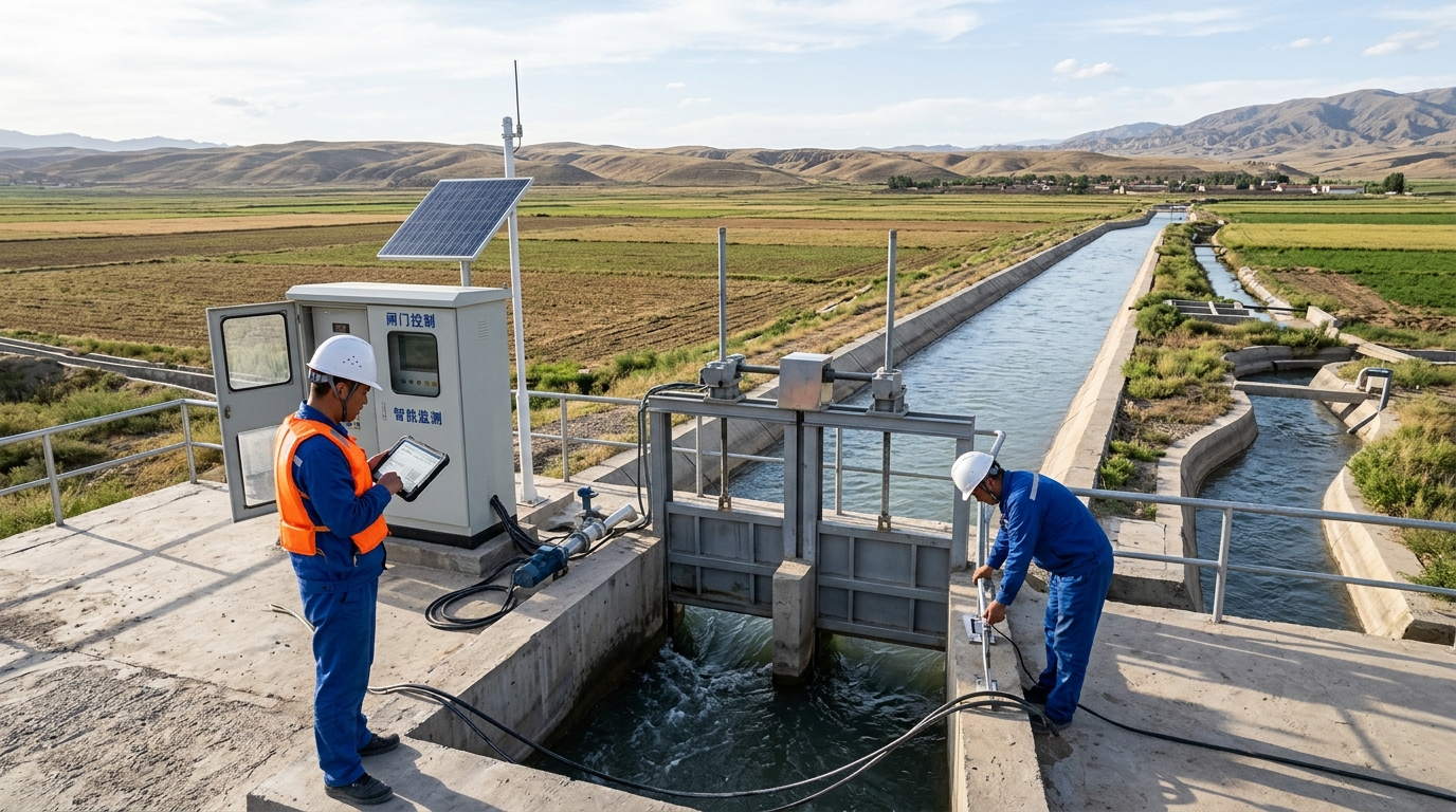
The core change of this project lies in water use management gradually shifting from “experience-based water release and relationship-based allocation” to “data-based allocation, model-based dispatching, and metering-based charging.” Centering on key aspects such as smart irrigation, water saving, water measurement, and informatization, the project built a four-layer system of sensing, transmission, platform, and application, incorporating hydrological conditions, agricultural conditions, infrastructure status, and water user demands into a unified data foundation. For medium-sized irrigation districts, such projects not only improve water resource utilization efficiency, but also provide a quantifiable basis for water use equity, water fee collection, and safe canal operation.
Project Background: Water Resource Constraints and Aging Canal Systems Force Management Upgrades
The district is located in a Yellow River diversion irrigation district in the middle reaches of the Yellow River in Northwest China. It mainly grows wheat, maize, cotton, and potato, with concentrated irrigation periods and pronounced water demand peaks. Before implementation, the district faced multiple pressures: on the one hand, total regional water resources are limited, and Yellow River inflows are significantly affected by flood season, low-flow season, and upstream dispatching; on the other hand, the canal system was built relatively early, and some channels suffer from leakage, sedimentation, weed overgrowth, and cross-section deformation. The original water measurement facilities were few and unevenly distributed; the canal head and main canals had certain metering conditions, but the metering coverage rate for branch canals, lateral canals, and field-level tail ends was less than 40%, and a large amount of water use data relied on manual reading and empirical estimation.
Coarse management also led to water use conflicts. Before the project started, water user associations, village collectives, and farmers in the district often had disputes over water release timing, water volume allocation, and water fee settlement. Due to the lack of real-time metering and process records, dispatchers found it difficult to accurately judge the conveyance capacity of a channel, the water demand status of a field plot, and the actual water use of an irrigation event. The water fee collection rate remained around 79% for a long time, and some water users had low acceptance of extensive charging methods such as “charge per mu” and “charge per outlet.” At the same time, the irrigation district management office had to invest a large amount of manpower in canal patrol, gate operation, and water volume statistics, and management efficiency was clearly constrained.
Technical Challenges: Water Measurement Accuracy, End-Point Sensing, and Multi-Source Data Fusion
Informatization of irrigation districts is not simply installing sensors and cameras; its difficulty first appears in water measurement accuracy. Open-channel flow conditions are complex, and the stage-discharge relationship fluctuates with changes in canal roughness, sedimentation thickness, weeds, cross-section deformation, and sediment concentration. Early project inspection showed that the error of some old water measurement facilities exceeded 8%, and under low flow, sediment-laden flow, and winter freezing conditions, data stability was even worse. If metering data are inaccurate, subsequent water allocation plans, fee settlement, and water-saving evaluation will lose their basis. Especially because lateral outlets and tail-end canal systems are numerous and scattered, traditional manual flow measurement cannot meet the requirements for high-frequency, full-process recording.
"The second difficulty is insufficient end-point sensing and communication/power supply conditions... The third difficulty is multi-source data fusion."
The second difficulty is insufficient end-point sensing and communication/power supply conditions. The canal system crosses farmland, desert, villages, and traffic roads; some points are far from villages, mains power coverage is unstable, and the proportion of points without mains power or with a power supply radius exceeding 3 km is about 31%. At the same time, remote canal sections suffer from weak 4G signal, network fluctuation, and lightning interference. If every monitoring point uses high-power equipment or requires frequent manual maintenance, the operating cost will increase significantly. The third difficulty is multi-source data fusion. The project needs to integrate data such as hydrology, meteorology, canal flow, gate status, soil moisture, cropping structure, water rights allocation, and water user information, but the data formats, time scales, and spatial coding from different sources are not unified. A standardized data model must be established; otherwise, the platform can only become a “data display interface” and is difficult to support dispatching decisions.
Solution: Building an Integrated “Water Network—Sensing—Platform—Service” System
The project adopts an integrated “water network—sensing—platform—service” architecture. The sensing layer was deployed according to the principles of “total volume control, tiered metering, and traceable process”: high-precision metering cross-sections were set at the canal head and main canals; smart gate control and flow monitoring were configured at branch canal diversion outlets; low-power flow meters, level meters, and video surveillance were installed in lateral canals and tail-end canal systems. For open-channel flow measurement, the project selected radar flow meters, ultrasonic open-channel flow meters, and electromagnetic flow meters according to canal conditions, and performed field calibration of the stage-discharge relationship. Soil moisture monitoring points cover major crop planting areas, and small weather stations provide rainfall, evaporation, wind speed, and temperature data, providing a basis for smart irrigation and water demand forecasting.
The platform layer focuses on solving data governance and business coordination. The project established a unified spatial base map, equipment coding, and water user ledger, and incorporated channel cross-sections, gate locations, water measurement facilities, land rights confirmation information, and cropping structure into a GIS platform. The system integrates hydrological forecasts, meteorological data, canal conveyance capacity, and crop water demand models to form irrigation dispatching recommendations. For allocation plans, the platform can generate three-tier water use plans for main canals, branch canals, and lateral canals based on inflow forecasts, soil moisture, crop growth stages, and canal conveyance capacity, and issue alerts for abnormal flow, over-plan water use, gate faults, and canal water-level limit exceedance. The application layer provides mobile services for the management office, water user associations, and farmers, supporting water use declaration, plan inquiry, metering viewing, water fee settlement, and fault reporting.
Key Deployment Metrics
- 448 water measurement facilities
- 146 smart gate control points
- 512 hydrological & soil moisture points
- 368 video surveillance channels
System Architecture Layers
- Sensing: Tiered metering & traceable process
- Transmission: NB-IoT & 4G hybrid networks
- Platform: Unified data foundation & GIS
- Application: Mobile services for all stakeholders
Implementation Process: From Pilot Canal System to Phased Launch Across the Entire Irrigation District
Project implementation was divided into four phases: baseline survey, pilot validation, full-scale promotion, and operation evaluation. The baseline survey lasted about 3 months. The project team completed the update of 1:2,000 topographic maps for the irrigation district, canal cross-section surveys, compilation of historical water volume records, and verification of water user information, and sorted out about 1.86 million historical water-use records over the past five years and information on more than 3,200 canal facilities. Through data cleaning, the project established relationships among canals, gates, water measurement facilities, crop plots, and water users, providing basic data support for subsequent dispatching and billing. To address cross-section deformation of aged canals, the project also performed dredging, repair, and calibration of 46 critical water measurement cross-sections.
To reduce the risk of full-scale rollout, the project selected the seventh branch canal as a pilot. This branch canal controls an irrigation area of about 46,000 mu, has a relatively typical canal structure, and involves 12 metering points, 38 monitoring points, and 16 smart gates. During the 3-month pilot operation, the team focused on calibrating stage-discharge relationships, optimizing the combination of solar power, NB-IoT communication, and 4G transmission, and verifying the reliability of remote control of smart gates. The pilot showed that under sediment-laden flow conditions, the error of radar flow meters could be controlled within ±4% after field correction, and the communication success rate reached 97.8%. Subsequently, the project used the winter repair period and the window before spring irrigation for phased promotion, avoiding the critical periods of wheat green-up, maize jointing, and cotton irrigation, and completed equipment installation, joint debugging, and personnel training across the entire district.
Final Results: Water Saving, Efficiency Gains, and Water Use Equity Improved Simultaneously
From operational results, the most direct effect of the informatization project is reflected in enhanced water measurement capability. The metering coverage rate across the entire district increased from less than 40% to 98%, and the data completeness rate for key canal sections reached 96.5%. Dispatchers can view the processes of canal head inflow, main canal conveyance, branch canal allocation, and lateral outlet water use on the platform. Previously, one branch canal allocation order required manual on-site operation, with an average response time of about 2.4 hours. After the system went live, the average response time of smart gates with remote control shortened to 11 minutes, and some canal sections achieved planned allocation, automatic adjustment, and process recording. For canal safety, video surveillance and water-level alerts can identify risks such as backwater, embankment breach, illegal water withdrawal, and gate jamming in advance. During the trial run, a total of 217 abnormal alerts were issued, of which 186 were effectively handled.
In terms of water-saving benefits, the irrigation water utilization coefficient of the district increased from 0.51 to 0.60, and average irrigation water use per mu decreased from 526 m³ to 458 m³, a decrease of about 12.9%. Based on an effective irrigation area of 583,000 mu, annual water saving is about 39.6 million m³, equivalent to reducing diversion demand by about 12.4%. In terms of water supply guarantee rate, the district improved from 94.2% before the project to 97.1%, and water-shortage complaints during critical wheat, maize, and cotton irrigation periods decreased significantly. Sample surveys showed that average yield per mu increased by about 3.8%, 4.1%, and 5.2% for major crops, respectively. However, yield changes are influenced by variety, fertilization, and meteorological conditions, so the project side treats them as auxiliary reference rather than a single attribution indicator.
Management Benefits: Improved Water Fee Collection, Patrol Efficiency, and Water Use Equity
Informatization also changed the management mode of the irrigation district. Before the project, water fee collection relied on manual estimation and concentrated reminders, with a collection rate of about 79%; after the project, lateral outlet metering, water use records, and online settlement gradually replaced extensive charging, and the water fee collection rate increased to 96%. Water users can query via mobile the water use volume, gate opening time, and fee details for an irrigation event, and disputes shifted from “verbal explanation” to “data verification.” During the trial run, the number of water-use disputes decreased by about 37% year-on-year, and among complaints and inquiry tickets received by the management office, issues related to water allocation and charging basis decreased significantly.
At the O&M level, the system reduced a large amount of manual meter reading and on-site operation. Before project operation, the management office needed to arrange about 180 person-times per month for canal patrol, water volume recording, and gate operation; after the project went live, routine patrol frequency decreased by about 32%, and personnel shifted more to equipment maintenance, canal dredging, and emergency response. For points without mains power, the project adopted a combination of solar panels, lithium batteries, and edge computing terminals; equipment can operate for about 7 days under continuous rainy conditions, reducing frequent maintenance costs. The project also established equipment health records and performed status monitoring of flow meters, gates, batteries, and communication modules; the average fault detection time was shortened from several days to within 2 hours.
Outlook: Irrigation District Informatization Deepens Toward Smart O&M and Water Governance
From industry trends, irrigation district informatization is deepening from “building systems and viewing data” to “using models, optimizing dispatching, and strengthening governance.” The next phase of the project plans to improve crop water demand models and canal hydraulic models, combine weather forecasts, soil moisture, and cropping structure, and further improve allocation accuracy. In the future, AI image recognition may be introduced to automatically identify floating debris in canals, weed blockage, water-level exceedance, and illegal water withdrawal; drone inspection and robotic inspection may be introduced to improve patrol efficiency for remote canal sections. For smart irrigation, the project plans to link field soil moisture, crop growth stages, and irrigation equipment status to form closed-loop control from the canal head to the field, reducing ineffective irrigation and deep percolation.
This case shows that the key to informatization of medium-sized irrigation districts is not only equipment installation, but establishing an operable, verifiable, and assessable water use management system. Water measurement is the foundation, smart dispatching is the core, water-saving evaluation is the objective, and the informatization platform provides full-process support. For more irrigation districts, replicable experience includes: first unify data standards and spatial coding, then deploy metering facilities in tiers according to canal system conditions; prioritize typical branch canal pilots, and after validating communication, power supply, and model accuracy, promote full-scale deployment; incorporate water rights allocation, water fee settlement, water user participation, and O&M responsibilities into project acceptance. As water resource constraints tighten and modernization of irrigation districts progresses, irrigation district informatization will continue to evolve toward greater refinement, intelligence, and governance.

