From Technical Challenges to Successful Implementation: A Case Study of a Smart Water Management Project
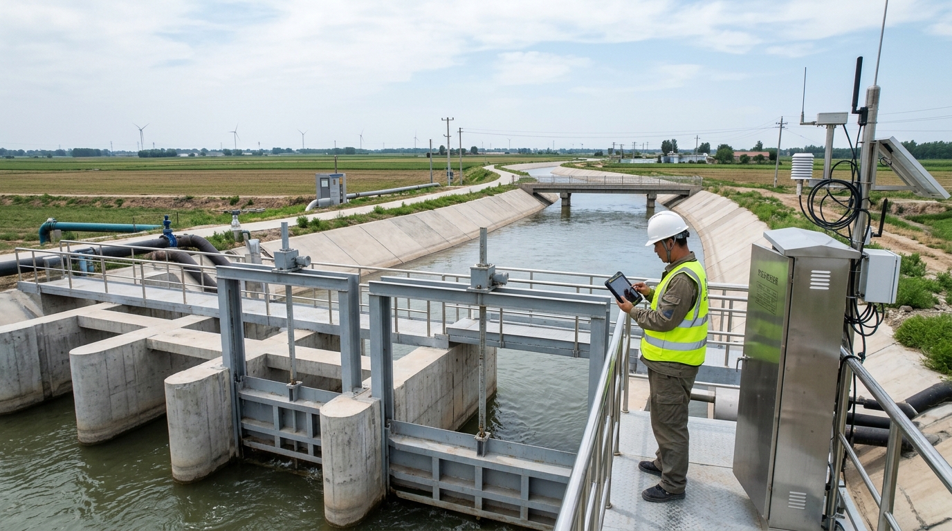
According to the project acceptance materials and operational data for the irrigation district, a medium-sized irrigation district in the North China Plain implemented an irrigation district informatization and smart irrigation renovation project in 2023–2024. The district has a designed irrigation area of 286,000 mu, a total main-canal length of approximately 186 kilometers, a designed flow rate of 25 cubic meters per second at the canal head, and an annual available water supply of approximately 112 million cubic meters. Centered on four main themes—water measurement, smart irrigation, water saving, and informatization—the project constructed online water-measurement facilities, remote gate control, soil-moisture and meteorological sensing, video surveillance, edge gateways, and an integrated irrigation district management platform. After commissioning, the district’s metering coverage rate increased from approximately 28% to 98.6%, the canal-system water utilization coefficient improved from 0.52 to 0.68, the average irrigation water use per mu decreased from 380 cubic meters to 310 cubic meters, and approximately 20 million cubic meters of irrigation water were saved annually. An informatized irrigation management system that is calculable, dispatchable, and traceable has been initially established.
1. Project Background: Pain Points of Traditional Irrigation District Management
The irrigation district is located in the Huang-Huai-Hai Plain, a major agricultural production area, where winter wheat and summer corn are the main crops. The multiple-cropping area is approximately 286,000 mu, involving 12 townships, 86 administrative villages, and about 31,000 water users. Water is diverted from a river at the canal head and distributed progressively through main canals, branch canals, and distributaries. Canal-system structures include control gates, diversion gates, waste gates, aqueducts, drops, culverts, and measuring weirs and flumes, totaling more than 210 sites. Because many facilities were built at an early date, some canals suffer from leakage, sediment deposition, cross-section deformation, and aging structures.
Before project implementation, district management was still dominated by manual patrols and paper records. Only one manual gauging section was available at the canal head, the coverage rate of turnout metering points was less than 30%, and diversion below branch canals relied mainly on experience-based judgment.
During peak irrigation, managers had to patrol canals one by one and manually adjust gates; a single water-allocation command took an average of 2 to 3 days to be transmitted from the dispatch room to a turnout. Due to insufficient metering facilities, water-fee collection had long relied on area-based charging or estimated charges, water users raised disputes over fairness, and the water-fee collection rate was approximately 72%.
In terms of water-use structure, the district’s annual diverted water volume is approximately 112 million cubic meters, of which agricultural irrigation accounts for more than 85%. Before the project, the canal-system water utilization coefficient was 0.52 and the effective utilization coefficient of irrigation water was 0.58, lower than the level of more than 0.70 in advanced irrigation districts in the region. With groundwater over-extraction control and comprehensive agricultural water-price reform advancing, the district needs to shift from water-supply management to water-use management, from area-based charging to volumetric billing, and from experience-based dispatch to data-driven dispatch. Therefore, building a water-measurement system, smart gate control, and an irrigation district informatization platform became the core project needs.
2. Technical Challenges: Transition to “Can Measure, Can Control, Can Analyze”
Irrigation district informatization is not simply the installation of sensors and software; the first priority is to solve the accuracy problem of open-channel flow measurement. The canal cross-sections in this district are complex, including trapezoidal, rectangular, curved-bottom, and locally nonstandard sections. Flow rates in main canals are mostly between 1 and 8 cubic meters per second, while turnout flow rates are often below 0.5 cubic meters per second. Under low-flow conditions, water-level fluctuations are small and velocity distribution is uneven, making it difficult for a single water-level gauge to accurately convert water level to flow rate. Some canals have aquatic plants, floating debris, and sediment deposition, which easily affect the stability of weirs and flumes, ultrasonic probes, and radar flow meters.
Communications & Power Supply
The canal system is dispersed, with unstable 4G coverage in peripheral areas. Solar power schemes face challenges with battery endurance during continuous rain or low temperatures, requiring redesigned equipment protection and lightning grounding.
Retrofitting Old Gate Systems
18 gates require remote control. Many lack opening feedback or have aging control cabinets. Direct addition of electric actuators risks jamming or overload without closed-loop control and over-torque protection.
The fourth challenge is multi-source data fusion and model localization. Meteorological stations provide evaporation, rainfall, wind speed, temperature, and humidity data; soil-moisture stations provide soil water content; video surveillance provides on-site imagery; water-measurement facilities provide water level, flow rate, and cumulative water volume; gate systems provide opening and operating status. Protocols differ among equipment vendors, and data sampling frequencies and spatial locations are not unified. If smart irrigation models directly adopt generic parameters, they can hardly accurately reflect local soil types, cropping structures, and canal conveyance characteristics; therefore, local calibration and field validation are required.
3. Overall Solution: Building a Four-in-One System
The project adopts a layered architecture. The sensing layer is responsible for data acquisition and execution control; the transmission layer is responsible for data uplink and command downlink; the platform layer is responsible for data governance and business computing; and the application layer provides operation interfaces for the district management office, grassroots water managers, and water users. The overall goal is to prioritize building the foundational capabilities of “accurate measurement, clear visibility, effective adjustment, and transparent calculation” without changing the basic canal-system layout.
- Sensing Layer: Includes 26 water-measurement facilities, 18 smart gates, 22 video-surveillance points, 2 small meteorological stations, 26 soil-moisture stations, 12 groundwater-level monitoring wells, and 4 water-quality monitoring points.
- Transmission Layer: Adopts a hybrid “fiber-optic backbone plus wireless last-mile” network architecture. 38 kilometers of fiber-optic cable form a backbone ring network, while remote turnouts connect via 4G or NB-IoT. Edge gateways handle protocol parsing and breakpoint-resume retransmission.
- Platform Layer: Builds an integrated cloud platform with a data middle platform, GIS one-map, device management, dispatch, irrigation forecasting, and mobile applications.
The data middle platform unifies the access of water level, flow rate, gate opening, soil moisture, meteorological data, video, and water-user information, forming a relational model of “canal—structure—cross section—zone—water user.” The GIS one-map spatially maps canals, gates, water-measurement facilities, monitoring wells, and planting zones, allowing managers to intuitively view incoming water, diverted water, water demand, and abnormal points.
4. Water Measurement Facilities: Precision and Traceability
Water measurement is the foundation of irrigation district informatization and water-saving management. The project arranges metering points according to the concept of “total volume at the canal head, process measurement at branch canals, and end-use measurement at turnouts.” The canal head uses a broad-crested weir combined with an ultrasonic level gauge, and a radar flow meter is configured for verification. The designed flow rate at the canal head is 25 cubic meters per second, while normal operating flow rates range from 5 to 20 cubic meters per second. The water-level measurement accuracy reaches ±1 millimeter, and the flow-measurement error is controlled within ±2% of full scale. Cumulative water volume at the canal head serves as the basis for accounting the total diverted water volume of the district.
Main-canal and branch-canal diversion points use combinations of Parshall flumes, rectangular thin-plate weirs, and V-notch weirs. For canals with irregular cross-sections where new weirs or flumes cannot be built, Doppler ultrasonic flow meters or radar flow-measurement devices are used for auxiliary measurement. To ensure reliable flow measurement, the project conducted field calibration for the 26 water-measurement facilities, completing a cumulative total of 186 sets of cross-sectional flow comparison tests. After calibration, metering errors for main canals and branch canals were controlled within 5%, while errors for turnouts were controlled within 8%.
Smart Gate Control Integration
18 key gates were retrofitted with electric or hydraulic actuators, opening sensors, limit switches, and over-torque protection. The platform can remotely set gate opening and perform closed-loop adjustment based on target flow rate, achieving gate-opening control accuracy of ±1 centimeter.
5. Smart Irrigation: Precision Allocation Driven by Models
The smart irrigation module uses crop water requirement, soil moisture, meteorological evaporation, and canal supply capacity as core inputs. The project established growth-stage irrigation regimes for winter wheat and summer corn. Meteorological stations calculate reference crop evapotranspiration ET0, which, combined with crop coefficients Kc and effective soil moisture, forms irrigation forecasts and supplemental irrigation recommendations.
The platform divides the 286,000 mu of farmland into 12 rotation irrigation groups. When soil water content is below 65% of field capacity and rainfall in the next 72 hours is less than 10 millimeters, the system triggers an irrigation warning. Taking a branch-canal pilot as an example, the system identified a zone needing supplemental irrigation while adjacent zones did not. By executing targeted allocation, this single event reduced water use by approximately 12,000 cubic meters compared to traditional whole-area rotation irrigation.
Smart irrigation does not mean fully automatic replacement of manual work. The project retains manual review and emergency-control mechanisms, providing a closed-loop process of “recommendation—confirmation—execution—record” to facilitate water-fee accounting and responsibility tracing.
6. Implementation Process: Phased Construction and Pilot First
The total project duration was approximately 14 months, with total investment of approximately 28.6 million yuan. Funding sources included central water conservancy development funds, provincial matching funds, and local self-raised funds. Before implementation, the project team spent approximately 1 month completing field surveys. Subsequently, approximately 2 months were used to complete overall design and equipment selection.
To reduce risk, the project selected one branch canal as a pilot section. After 2 months of pilot operation, the team optimized low-flow measurement, gate-opening feedback, and network-disconnection retransmission. The full construction phase lasted approximately 8 months, adopting “sectional construction, temporary diversion, and nighttime commissioning” to minimize impact on water supply. After equipment installation, an approximately 2-month integrated commissioning phase focused on testing data consistency and load performance.
Acceptance materials showed that the system operated continuously and stably for 90 days, the online device dropout rate was less than 1.5%, the data completeness rate reached 99.2%, and the average latency from platform command issuance to gate execution was less than 5 seconds.
7. Final Results: Water Saving, Efficiency, and Management Improvement
After one year of operation, the district’s metering capability improved significantly. The online operation rate of the 26 water-measurement facilities reached 98.6%. Three-level water-volume data at the canal head, branch canals, and turnouts can all be queried online. The canal-system water utilization coefficient increased from 0.52 before the project to 0.68 after the project. Average water use per mu decreased from 380 cubic meters to 310 cubic meters, saving approximately 20.02 million cubic meters of irrigation water annually.
Management efficiency also changed dramatically. Routine water-allocation commands can now be issued to smart gates within 2 to 4 hours (previously 2-3 days), and inspection mileage decreased by approximately 45%. In terms of agricultural benefits, wheat yield per mu increased by approximately 4.7%, and summer corn yield per mu increased by approximately 4.9%. The water-fee collection rate increased from 72% to 91%, and water-user complaints decreased by 62%.
8. Outlook: Evolving Toward Digital Twins
This irrigation district project shows that the key to informatizing traditional irrigation districts is not the number of devices, but whether a closed loop of “accurate measurement, reliable transmission, effective control, transparent calculation, and practical application” can be formed. In the next phase, the district plans to advance digital twins and refined dispatch based on existing data. The project has accumulated more than 90 days of continuous operation data, providing samples for training canal hydraulic models, gate dispatch models, and crop water requirement models.
For similar irrigation districts, this case provides a referenceable engineering path: first complete the three-level water-measurement layout, then advance remote gate control and smart irrigation; conduct special calibration for low-flow turnouts; use a combination of fiber-optic backbone and wireless last mile; and retain manual confirmation and emergency control. As agricultural water-saving policies continue to advance, irrigation district informatization will move from single-point monitoring to full-process dispatch, providing stable support for intensive utilization of regional water resources.

