In-Depth Comparison of Four Information Technology Approaches for Irrigation Districts
Introduction: From "Having Data" to "Being Able to Dispatch"
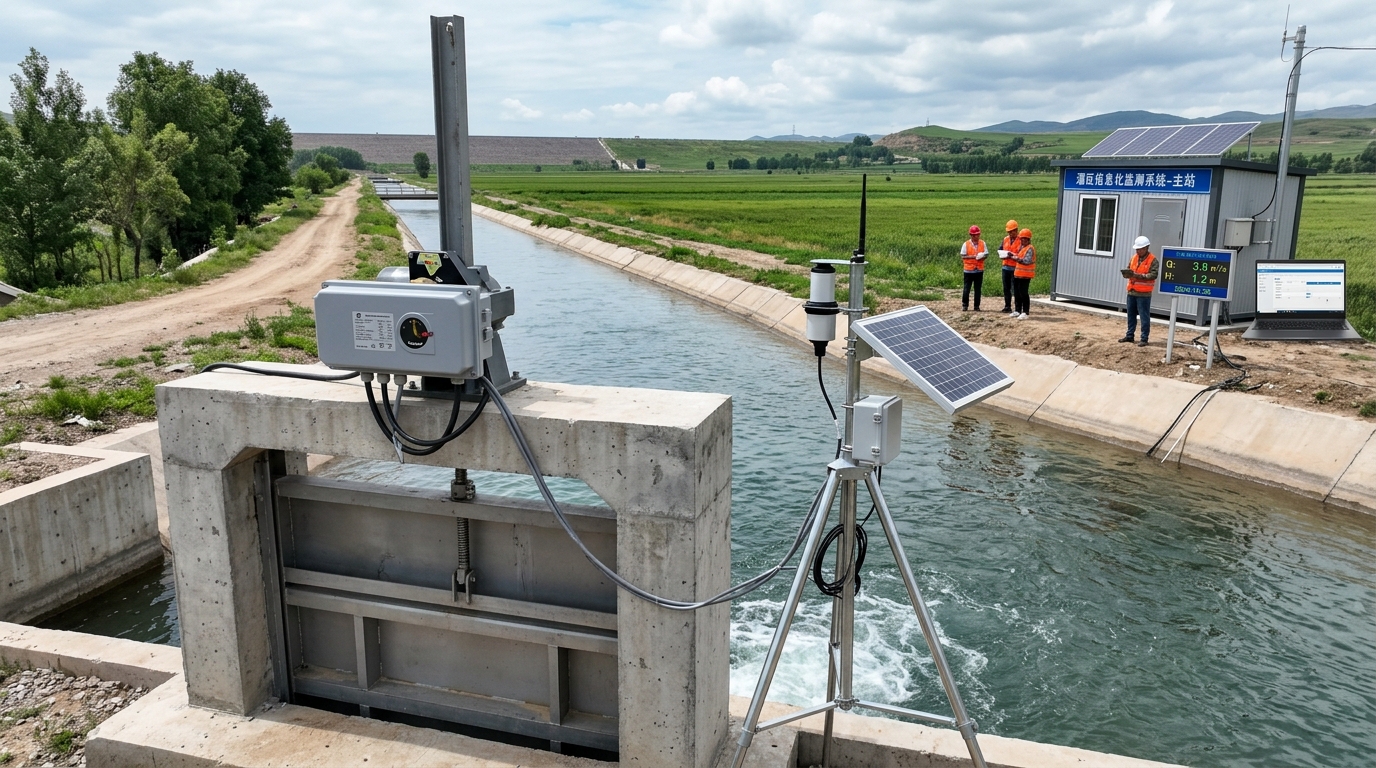
Irrigation district informatization is not simply installing water meters, cameras, and software platforms at canal headworks, nor adding a few statistical reports to management interfaces. As the continuation, supporting construction, and modernization renovation of large and medium irrigation districts are continuously advanced, irrigation district management is shifting from “manual patrol, experience-based water allocation, and post-event statistics” to a comprehensive business system covering “water measurement, remote control, intelligent dispatching, water rights and fees, and water-saving evaluation.”
For management authorities, the real difficulty lies not in whether data are collected, but in whether data can enter closed-loop processes such as water allocation plans, gate control, water fee collection, crop irrigation, and performance assessment. Different irrigation districts vary greatly in water source conditions, canal system structures, topography, crop types, fiscal capacity, and management foundation, making it difficult to cover all scenarios with one unified solution.
This article revolves around four keywords—smart irrigation, water saving, water measurement, and informatization—and compares the advantages, disadvantages, applicable scenarios, and selection recommendations of various technical routes.
1. Manual vs. Automated Water Measurement
Manual Water Measurement
- Method: Flow cross-sections, staff gauges, current meters, weirs.
- Pros: Low investment, low technical threshold.
- Cons: Poor timeliness, operator dependency, hard to audit.
Automated Water Measurement
- Devices: Electromagnetic/Ultrasonic flowmeters, radar level transmitters.
- Accuracy: Class 0.5 (EM), ±1-2% (Ultrasonic).
- Value: Turns “visible water” into “calculable water” for billing and dispatching.
A case study of a medium irrigation district (approx. 34,700 ha) demonstrated that deploying 126 automated metering points increased the canal system water use coefficient from 0.55 to 0.62. Annual water savings reached ~12 million m³, and the water fee accounting cycle shortened from 30 days to 7 days. However, winter ice and floating debris required robust maintenance protocols.
Recommendation: Prioritize automated metering at dry and branch canal gates. For smaller districts or limited budgets, combine automated main canal monitoring with manual tertiary verification.
2. SCADA/PLC Centralized Control Route
The SCADA/PLC route targets backbone projects like gates, stations, and pumps. It relies on fiber-optic industrial Ethernet, PLC/RTU cabinets, and central dispatching platforms. Its primary advantage is high reliability and second-level response times, essential for closed-loop dispatching.
In a large irrigation district, adopting PLC centralized control reduced water allocation deviation from ±12% to ±4% and cut manual gate visits by 60%. Communication latency was controlled within hundreds of milliseconds via Modbus TCP/OPC UA.
Key Challenges
- High Cost: Backbone nodes can cost CNY 80,000–150,000 each.
- Civil Works: Fiber laying and power introduction extend schedules.
- Scalability: Not economical for dispersed tertiary canal gates.
Selection Strategy: Use wired PLC for main canals and key hubs. Reserve wireless or semi-automatic solutions for terminal small gates to optimize budget allocation.
3. Wireless Sensing: LoRa/NB-IoT/4G/5G
Wireless routes enable rapid coverage of dispersed water intakes. LoRa suits low-frequency, long-distance reporting; NB-IoT leverages operator networks for scattered terminals; 4G supports video/bandwidth-heavy tasks; 5G offers potential for ultra-low-latency control but faces coverage/cost constraints.
A hilly district with 380 tertiary intakes achieved 92% water measurement coverage using a hybrid NB-IoT/LoRa/4G solution. Water fee recovery rose from 78% to 91%, with a deployment time of just three months.
Best For
Tertiary canals, dispersed intakes, mountainous areas, budget-constrained renovations.
Considerations
Interference, battery degradation, signal fluctuation. Requires edge caching and retransmission mechanisms.
Combination Principle: “Wired backbone, wireless terminal, dual links for critical points, low power for ordinary nodes.”
4. GIS and Digital Twin Route
GIS/Digital Twin maps sources, canals, parcels, and crops onto a spatial base map. True value lies not in 3D display, but in model accuracy, data governance, and business closed loops.
In a large district integrating 1,800 points, initial model error was 15%. After one season of calibration using DEM/DOM data, error dropped to 5%. Allocation plan preparation time shrank from 2 days to 2 hours.
Warning: Without model calibration and feedback loops, digital twins risk becoming mere “big-screen projects” with no operational utility.
Implementation Path: 1. Data Governance → 2. Spatial Base Map → 3. Dispatching Simulation → 4. Visual Display. Start with core modules before expanding to full-element twins.
5. Smart Irrigation and Fertigation
This route focuses on field efficiency using soil moisture sensors, weather stations, ET0 models, and fertigation machines. Goals include precise execution, water/fertilizer savings, and yield improvement.
Performance Metrics
- Water Saving: 20%–35%
- Fertilizer Saving: 15%–25%
- Yield Increase: 5%–12%
- Sensor Accuracy: ±3% (Soil Moisture)
A facility agriculture project saved 1.8 million m³ annually and reduced fertilizer use by 16% across 800 ha. Success depends on local parameter calibration and agronomic services, not just hardware sales.
Applicability: Greenhouses, orchards, high-efficiency zones. Must be integrated with gate-opening metering and water pricing reforms to avoid isolated equipment stacking.
6. Video Sensing and Drone Inspection
Addresses “visibility and rapid response.” AI video identifies water levels, debris, illegal withdrawals, and damage. Drones inspect long distances and hazardous terrain.
An irrigation district with 120 km of dry canals reduced daily flood-season patrol time from 8 hours to 2 hours using 28 AI-enabled video points. Illegal withdrawal recognition hit 90% accuracy after sample training.
Limitations & Solutions
- False Alarms: Initial rates up to 20%; requires seasonal model training.
- Environment: Night/rain degrades image quality.
- Action Loop: Results must auto-generate work orders to be effective.
Strategy: Fixed video for key nodes; drones for periodic branch/tertiary inspection. Prioritize edge computing and alarm interlocking over camera quantity.
7. Selection Recommendations & Future Outlook
There is no single best route. Projects should combine technologies based on scale and objectives:
Large Backbone
Fiber SCADA/PLC + Auto Metering + GIS Twin + Video.
Medium Districts
Auto Metering + Wireless Sensing + Dispatch Platform.
Field Areas
Smart Irrigation + Fertigation + Soil Sensors.
A comprehensive project example (CNY 28M investment) showed significant gains: Water use coefficient rose from 0.55 to 0.63, fee recovery hit 96%, and personnel needs dropped by 45%. Key indicators to track include device online rate, data completeness, and control success rate.
Future Trends:
- Whole-Process Accounting: Moving beyond single-point metering to full-chain water balance.
- Model-Assisted Dispatching: Integrating digital twins and crop models for decision support.
- Long-Term Service: Shifting focus from delivery to ongoing calibration, data governance, and cybersecurity.
Truly effective informatization makes water measurement accurate, allocation fast, savings substantive, fees clear, and smart irrigation deployable.

